Secwepemc (pronounced Se-KWEP-umk-wh) means “The People”. Early settlers had trouble pronouncing the word and chose to say “Shuswap” instead.
The Secwepemc Nation encompasses 17 bands located in BC’s Southern Interior.
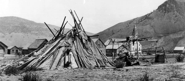
The traditional Secwepemc were semi-nomadic. In the winter, they lived in warm, semi-underground “pit-houses” and during the summer, they lived in mat lodges made from reeds.
The traditional Shuswap economy was based on fishing, hunting, and trading. Their diet consisted of fish, meat, berries and roots.
Their way of life was based on respect for nature, and depended on traditional Aboriginal skills and knowledge that was passed down from generation to generation through oral tradition.
Land maps showing the traditional boundaries of the Secwepemc people, where and how far they travelled and traded during their semi-nomadic lifestyle. Maps identifying how many Secwepemc bands/tribes are left and where their reservations are located and their traditional territories.
The traditional and recognizable land markers that designate the Secwepemc territory are the “Coyote Rocks.”
The Coyote rocks are large visual land markers the Secwepemc people used to mark their traditional territories. Description: Large mound of earth and/or rock with a large rounded rock balancing on top of the other.
The Secwepemc Museum –albeit a great physical resource to visit to see their permanent and seasonal exhibits also has online resources. In particular, their website has a “history page” for the Secwepemc.
Link to Website: http://www.secwepemcmuseum.com/our-museum/history